Basic Map Skills 101: A Simple Guide for 6th Graders
If you’ve ever tried teaching basic map skills to 6th graders, you know it can be a bit like navigating uncharted territory. Those directions, scales, and labeling can leave your students feeling more than a tad lost. Don’t fret, I’ve got your back. I’m sharing all the details on how to tackle the ins and outs of maps from the beginning of the school year. This map skills “boot camp” is such a great way to lay the expectations for maps from the beginning of the year and it sure pays off later in the year too! Ready to send your students to map skills boot camp? Keep reading for all the details!

In this blog post, we’ll dive deep into map skill norms and activities you can do to ensure your students get a rock-solid grasp of essential map skills. I’ve got everything covered, from directions to mastering those labeling techniques. The best part? They will transform your students into confident, consistent map readers and labelers. So, grab your compass because we’re about to embark on a journey into the world of map skills!
The Importance of Teaching Basic Map Skills in 6th Grade
Transport back in time to the first days of school. You’re at the start of a new school year and have a classroom full of bright-eyed 6th graders.

Learning about basic map skills is likely one of the first units they will be navigating on their new learning journey.
I’m talking about understanding those mysterious directions, deciphering scales, mastering labeling, and getting creative with colors.
Ensuring your students nail map reading and labeling isn’t just a geography lesson. They will be interacting with maps all year long, so it is really a necessity.
Developing basic map skills improves their handwriting, makes their maps look neater and easier to read, and keeps grading consistent. It’s the secret that turns your rubrics into trusted guides so your students always know what’s expected.
Exploring My Basic Map Skills Resource
To make teaching map skills easy, I have put everything I use into the Basic Map Skills and Norms resource! This is your one-stop shop for all things map-related, tailor-made for 6th-grade teachers who want to make their lessons both effective and engaging. And. . . who doesn’t love to save some time and have quality lessons that are ready to print and use?
So, what’s in this Map Skills resource, you ask? Well, it’s packed to the brim with everything you’ll need to guide your students to become map reading and labeling pros. Each of the topics in this resource includes detailed teacher notes to help you plan your lesson. Here’s a sneak peek of what’s waiting for you:
1. Kicking it Off with Vocabulary
As with any skill, it is important to introduce students to key vocabulary and the first word I introduce is map. Then I have students draw a map of the classroom. This might seem like a silly exercise but we use it throughout the unit to reinforce what we are learning.
Then it’s time to dive into more vocabulary. I love starting here so that the proper terms can be used throughout the lesson. In this Map Skills unit, we start with vocabulary words like continent, label, and legend. We name the different parts of a map and different types of maps. It’s a great first lesson that connects well to just exploring a variety of maps.
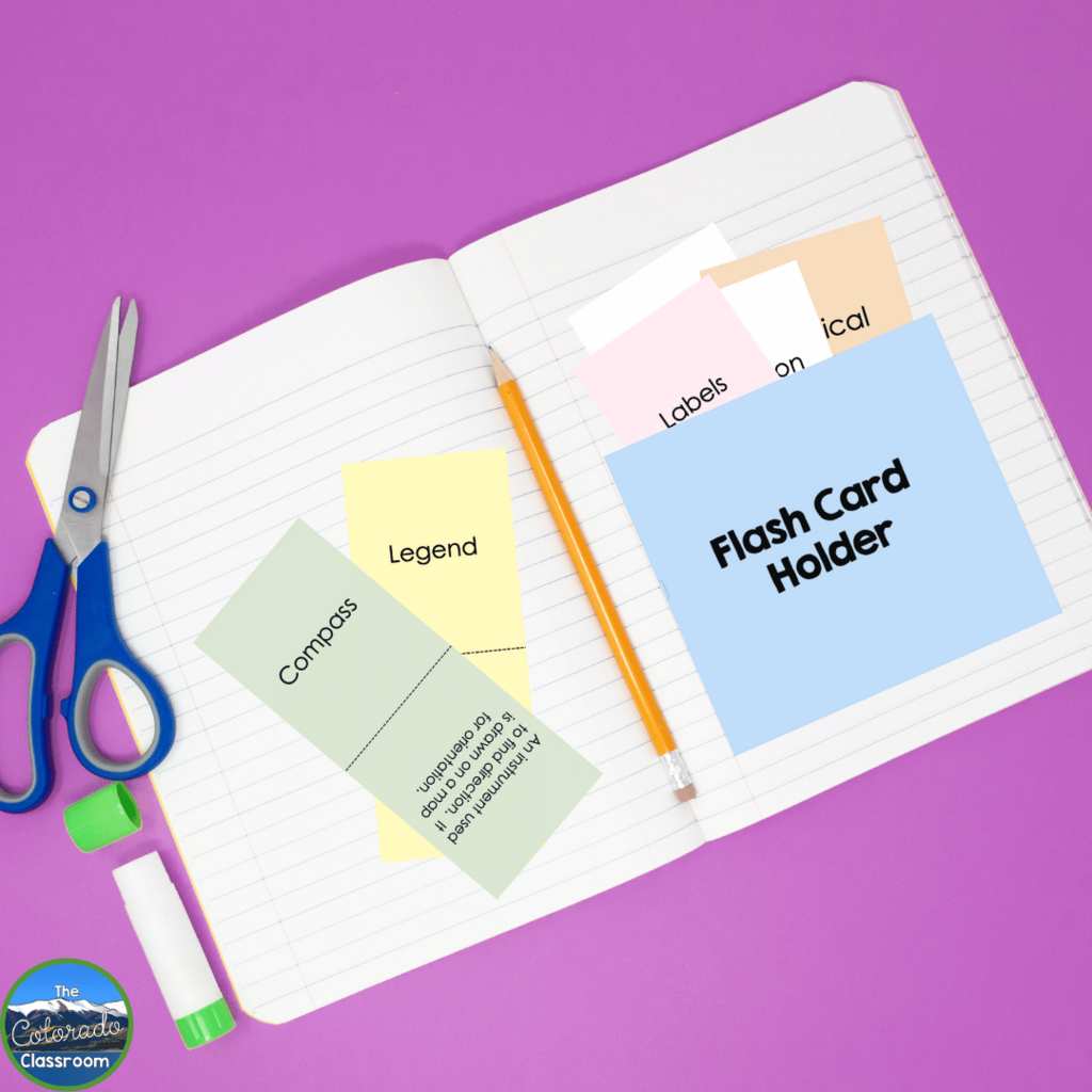
It can be hard to learn lots of new vocabulary at one time. And. . . learning vocabulary and definitions can be a bore, right? Not anymore. I’ve created printable flashcards that turn the drudgery into a game. Each student creates a foldable flashcard holder that can be added to their interactive notebook (or a sheet of paper if you don’t use notebooks). Then they can refer back to these important words as needed throughout the unit.
And refer back we do! Once I introduce the vocabulary I hold students responsible for using the correct terms. No more pointing to the compass rose and referring to it as “that pointy arrow thing.”
2. Understanding Cardinal Directions
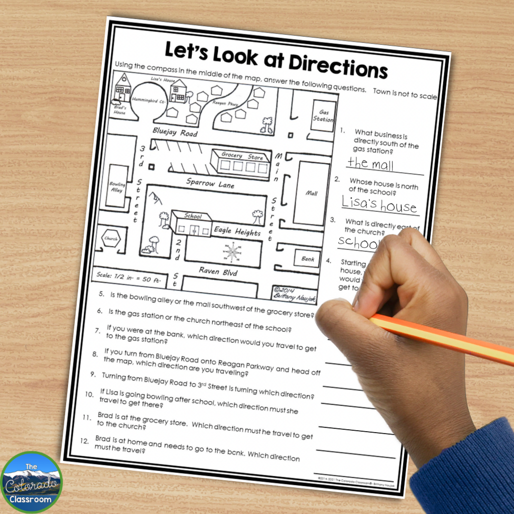
Speaking of “that pointy arrow thing”, learning cardinal directions and how to use the compass rose is next on the list. In the day of GPS, the understanding of cardinal directions has gotten lost. But no worries, with crystal-clear explanations and interactive exercises, your students will be compass pros in no time.
It’s always fun to watch the look on students’ faces when they hear directions to a location being given using cardinal and intermediate directions. Some look confused while others look quite impressed. But when they find out that right, left, and recalculating are not official directions they can’t believe it.
Learning to speak the language of maps takes some practice. So we dive right in with some interactive practice activities. The Map Skills resource has a no prep printable that is ready to print and use. Your students will love reading the map the “right” way and putting their new vocabulary to good use.
By the time you are done with this lesson, they’ll ace not only cardinal directions but intermediate directions too. They will also understand how these directions relate to maps and the world around them.
3. Let’s Talk About Scale
Another mind-blowing topic in the world of maps for upper elementary and middle school students is that of scale. Without fail, when I tell the students we are going to learn about scale, the kids start looking around for a scale that weighs things. It’s the perfect segue to connecting the concept of scale to measurement – just not the kind the kids were thinking of.
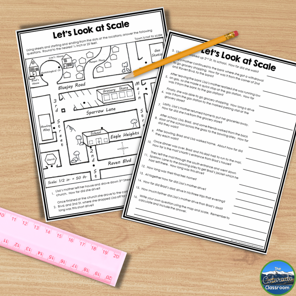
The concept of scale can be difficult to understand. That’s why I love to begin with lots of examples that have nothing to do with a map. Instead, I begin with toys. Toy vehicles and models often come with the scale written right on the packaging. Most of my students never knew what this meant until our lesson.
When those light bulbs start going off with the concept of scale, it is time to introduce the scale on a map. The students are amazed when they realize that there’s more to a map than just being a small drawing of a place.
When we dive into scale, students get to experience just how much you can see on a map. We dig out those rulers and get busy measuring and discussing scale. When students learn that scale is a magical shrink ray for geography, things start clicking.
It’s fun to have them return to their map of the classroom that they drew on the first day of our map unit. Now that they know about scale I like to ask them what they would change. If you have time, they can even redraw their classroom map to scale.
4. Let’s Talk About Labeling
Next up it is time to dive into the world of map labels. Labels are so important, yet on a classroom map activity, you are lucky if you can even read them. That’s why labels and labeling are part of the map skills boot camp.
Instead of just telling students to label, we are going to take a step back and teach them how. It is very likely that they have never been taught this. I break labeling down into four easy rules. Once students learn these rules, the quality of their map labeling improves immensely.
Get ready for your students to become label perfectionists. The Map Skills resource includes my four rules for labels and activities to practice with. With a little guidance and direction, their labeling becomes top-notch. Students realize that neatness and organization are the name of the game here. And. . . they take it seriously.
To finish up our lesson on labeling we pull out that classroom map again. This time I don’t even have to say anything. Students just jump in adding labels that comply with the new rules they learned.
5. Color Matters
We finish up our deep dive into maps talking about color. I like to pull out a map that is colorful, but not in the traditional way. The water might be hot pink and the mountains blue. Then, I like to ask students what they see on the map. It doesn’t take long for someone to declare that the mountains are actually water. When I tell them that they are wrong they are flabbergasted. But you can’t stop there. You must ask them why they thought the mountains were water. They will undoubtedly tell you it is their color. And when they do, you can agree and explain that this is why color matters on a map.
Colors and coloring might seem trivial, but in the world of map skills, it’s an art form. I’ve put together 6 rules for coloring maps that make sure students use color to their advantage. Again, like with labeling, students likely have not been taught how to color maps. And just based on how well students respond to these rules, I know that they appreciate the guidance.
When it comes to maps and colors we do lots of practice. We explore maps and see what we can deduce about color and we learn the rules. These rules not only focus on color choice but also how to color to make the map make sense and be legible. What happens next is nothing short of amazing. Students who used to produce sloppy, scribbly, randomly colored maps create beautiful thought-out maps.
Wrap it Up

I love to wrap up the boot camp by creating a Map Skills Anchor Chart. The students guide the process to include what is important when reading, labeling, and coloring maps. We use some keywords to remind us what is important and add a picture or example as needed.
The anchor chart goes up on the wall where it remains for the rest of the year. I love watching students refer back to it throughout the year as they are doing map work. Since I started using this approach to teaching map skills, the overall quality and understanding of maps dramatically increased. The students might still moan and groan about a reading passage, but map work is a favorite activity year after year.
Charting a Course to Success with Basic Map Skills
In the world of 6th-grade Social Studies, map skills are the secret code to understanding and interpreting the world around us. Getting these skills down pat right at the beginning of the school year is setting the stage for an epic educational journey.
My upgraded resource is your trusty sidekick on this journey. Your kiddos will go from getting directions mixed up to confidently understanding directions, deciphering scales, mastering labeling, and creating maps that are not just informative but visually appealing.

With my comprehensive toolkit by your side, your teaching becomes a breeze. Your students’ learning experiences become a whole lot more enjoyable. No more surprises, no more grading headaches. You can confidently step into the world of basic map skills, knowing that you and your students are well-equipped to navigate it successfully!
Save for Later
Remember to save this post to your favorite geography or Social Studies Pinterest board to keep handy for your map skills unit!