Teaching Latitude and Longitude with Games
I always get a kick out of teaching latitude and longitude! It feels like we’re embarking on a treasure hunt every time we use coordinates to find a place or item. That thrill definitely brings out the kid in me! However, not all my students share my enthusiasm right off the bat. So, I’ve figured out a step-by-step approach that makes it fun and manageable for everyone.

When teaching latitude and longitude, I break it down into four steps. First, I start with teaching latitude and longitude in just one quadrant. Once my students have a solid grasp of that, we move on to two quadrants, then three, and finally, we tackle all four quadrants. After they’ve gotten the basics down, I like to strengthen their understanding with some engaging games. These games help them build confidence and have fun with the concept. Today, I’m sharing three of my favorite games for teaching latitude and longitude!
Why Do We Still Need to Teach Latitude and Longitude?
You might be wondering, with all the technology we have these days, why do I still need to teach latitude and longitude to my students? While technology is amazing, the basics, like latitude and longitude, still hold a valuable place in our classrooms. They equip our students with essential skills and knowledge that are both timeless and relevant in today’s world. Below are just a few reasons why these skills are still super important.

Understanding latitude and longitude gives our students a grasp of geography. It’s the building block for all their future learning about the world around them. When they can pinpoint a location using coordinates, they gain a better sense of place and how different parts of the world are connected.
Even in our tech-savvy world, there are plenty of situations where knowing how to read coordinates can be useful. And. . . we all know that there are times and places where even the best technology just doesn’t work. So while we rely on it in the day to day, having the skills to keep going when the tech doesn’t is important too.
Knowing how to find and read coordinates also helps our students in other ways. Whether it’s understanding how GPS works or following a map on a hiking trip, latitude and longitude are practical skills useful in real-life experiences. Learning about latitude and longitude also helps our students develop critical thinking and problem-solving skills. Plus, it’s a great way to bring in math and science concepts, making learning more interdisciplinary and robust.
Teaching latitude and longitude encourages curiosity and exploration. It opens up discussions about different cultures, climates, and global issues. Students become more aware of the world beyond their immediate surroundings, which helps them develop a sense of global citizenship.
Make Learning Fun with Games
When it comes to teaching, making learning fun is an absolute game-changer! Planning games into our lessons, especially for topics like latitude and longitude, has so many benefits for our students. It also makes teaching even more enjoyable for us too!

Games turn abstract concepts into something approachable and engaging. When our students play, they’re not just memorizing facts. They’re applying what they’ve learned in a hands-on, interactive way. This approach makes the learning stick because it’s connected to a positive experience.
Another big plus is the boost in motivation and enthusiasm. Let’s face it, not every student walks into class excited about coordinates. When we introduce a game, suddenly everyone wants to participate. Games tap into their natural love for play and competition, making them eager to learn and succeed.
Games also foster collaboration and communication. Many games require teamwork, which helps our students develop their social skills and learn from each other. They get to practice problem-solving together and build a sense of camaraderie.
Using games in the classroom also helps to cater to different learning styles. Some of our students are visual learners, others are kinesthetic, and some might prefer auditory learning. Games often tie in multiple senses and methods of engagement. This ensures that every student in our class has a chance to grasp the material in a way that suits them best.
Using Geography Skills to Teach Latitude and Longitude
Before we dive into the games, it’s important to make sure our students have a solid understanding of latitude and longitude. Taking the time to teach these concepts step by step makes a difference. Once my students grasp the basics, they’re ready to jump into the games with confidence and enthusiasm. So, let’s talk about how we can introduce latitude and longitude in a way that sets them up for success before we bring in the games.
I love using interactive activities, in general, to make geography lessons engaging and memorable. My Geography Skills Unit is a fantastic guideline for this. This unit covers everything from continents to time zones to important vocabulary. Here’s how I use the activities for latitude and longitude.
“X” Marks the Spot
One of my students’ favorite activities we do is called “X” Marks the Spot. It’s a chance for them to interact with their peers while practicing latitude and longitude.
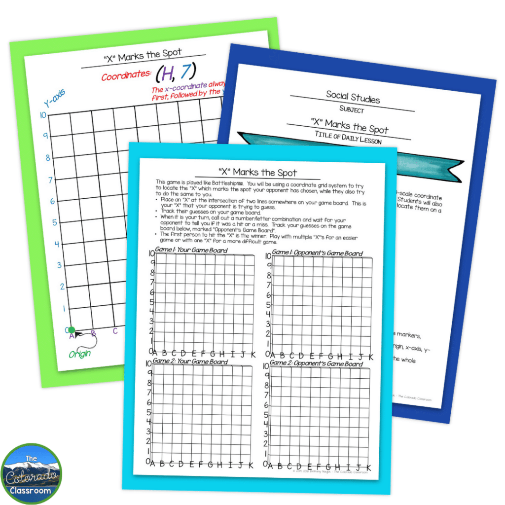
To start, I grab a large piece of chart or graph paper and a marker. I draw a simple coordinate system on it. I get the students involved right away by having them help label key points like the origin, x-axis, y-axis, and coordinate pairs. Once we’ve got our system set up, we practice labeling a few points on the grid so everyone can see and get some visual practice.
Next, I pair up the students and hand out an “X Marks the Spot” game page to each of them. They take turns calling out sets of coordinates and locating them on their grids. This hands-on practice is great because it reinforces the idea that you always move over before you go up or down.
I keep the energy high by letting the students play a few rounds. They can stick with the same partner or switch it up after each game. It’s all about getting plenty of practice with those coordinates.
To wrap up the lesson, we play a big game of “X Marks the Spot” as a class. I call out coordinates, and the whole class works together to guess the spot. It’s a fun way to see who’s got the hang of it. Sometimes, I even throw in a prize for extra motivation. It adds a bit of excitement and competition! This interactive and fun activity helps my students understand coordinates and by the end of the lesson, everyone’s learned a lot!
Coordinates of Our Country
Next up is one of my favorite activities, which is Coordinates of Our Country! This lesson is all about using latitude and longitude coordinates to find the states within the United States.

First, we review our anchor chart from the “X” Marks the Spot lesson. It’s a great refresher on how to call out and find coordinates on the grid. I show the students how we can replace the letters and numbers on our small ten-scale system with the actual latitude and longitude of the globe. To keep it simple, we usually stick to the northern hemisphere where we are located.
I then demonstrate with a few examples, showing how specific latitude and longitude coordinates point to different states. My students see how it all connects, which helps to make the concept much clearer.
After the demonstration, I hand out the Coordinates of Our Country student page. I have students work in pairs to use the given latitude and longitude to locate the states within the United States. Working together tends to help them grasp this new concept a bit more easily. As they work, I walk around the room checking in.
If we have enough time at the end of the class, we check the papers together as a class. This is where we discuss any tricky points and celebrate their successes. If we’re short on time, I collect the papers to review later. This activity shows students how latitude and longitude are used in the real world to find specific locations.
World Wanderings

The third activity for latitude and longitude in the unit is called World Wanderings. In this activity, I up the challenge with my students by having them use latitude and longitude coordinates on a four-grid system. They need to determine which country a set of coordinates is located in. They’ll also be given a city and will need to estimate its coordinates within a reasonable range.
We start the lesson off by reviewing the basics of latitude and longitude. We focus on how to call out and find coordinates on the grid. I then show my students how to expand from a single grid to a four-grid system using the four cardinal directions. This helps them understand how to pinpoint exact locations on the globe.
With a few demonstrations, I show them how these expanded coordinates can be used to find specific countries or cities. Then, I hand out the World Wanderings student page and pair them off. Their task is to work through the coordinates to find the country and then estimate the coordinates of a given city within a three or four-degree range. Working in pairs helps them learn from each other and makes the activity more interactive.
If time allows, we review the completed papers together as a class, discussing any challenges and celebrating their correct findings. If we’re short on time, I collect the papers to review later. This activity reinforces their understanding of latitude and longitude and gives them a fun, hands-on way to explore the world!
Latitude and Longitude Games To Try In Your Classroom
I’m excited to share with you the three games I use in my classroom to make learning these skills an absolute blast. These games not only reinforce the concepts but also keep my kiddos engaged and excited about geography.
Hit the Ships

Let’s look at the game Hit the Ships. This one is a classroom favorite that’s just like playing Battleship! This activity is a fantastic way to reinforce our understanding of coordinates while having a blast.
First things first, is getting the game boards set up. You can give each student a copy of the board or you can create a class set. Laminating the game boards allows them to be used with dry erase markers for years to come. When students play they need to be able to keep their grid hidden. I like to use file folders to create a “wall” between the two players. That’s the only prep needed for this game.
When it is time to play, I make sure each student has a game board and a few X markers or a dry erase marker. Each student places their X’s on their grid, keeping their coordinates a secret from their opponent.
Once everyone has their X’s in place, the real fun begins. I pair students up and they face off against each other. They take turns guessing the coordinates of their opponent’s X’s. When a student calls out a coordinate, their partner checks their grid and announces if it’s a hit or a miss. If it’s a hit, they mark it on their grid.
To keep the energy high, I encourage students to think strategically about their guesses, just like in the game Battleship. They learn to use their previous hits and misses to narrow down the possible locations of their opponent’s Xs. This helps them to practice their coordinate skills and promotes critical thinking and strategy.
Throughout the game, I circulate around the room, offering tips and cheering on the students. The excitement builds as students get closer to finding all their opponent’s X’s. Sometimes, I even add a twist by timing the rounds or introducing new rules to keep everyone on their toes.
At the end of class, we gather to discuss strategies and what they’ve learned about using coordinates. This reflection helps solidify their understanding and gives them a chance to share their experiences.
Where Am I?

One of my go-to games for teaching coordinates is “Where Am I?” or “Where Is Mrs. Naujok?” It’s a fantastic way to get my students comfortable with latitude and longitude while having a ton of fun.
I’ve created a deck of coordinate cards, each with a specific set of coordinates. Depending on what we’re focusing on, my kiddos have either U.S. maps or world maps in front of them. As the teacher, I read out a set of coordinates from my deck. My students then use their maps to figure out where those coordinates lead. They shout out the state, country, or city they think I’m in. It’s a race to see who can find the location first, which keeps everyone engaged and eager to participate.
What I love about this game is its flexibility. We can play it repeatedly, and each time, my students get more precise with their latitude and longitude skills. As they become more familiar with the maps and the coordinate system, their confidence grows. They start recognizing patterns and getting quicker at pinpointing locations. I often add layers of difficulty as we go, perhaps by choosing more obscure locations or by providing fewer hints. This challenges my students and keeps the game exciting and purposeful.
Beach Ball Review Game
My students’ all-time favorite review game is the Beach Ball Review. It’s not every day that throwing an item across the room is acceptable! This is a great way to get students moving and thinking about geography in a fun and interactive way.

I blow up a big beach ball and get it ready for some tossing action. Using a wet-erase marker or a Sharpie, I write 30-60 questions all over the ball. These questions can cover anything we’ve learned about geography, including coordinates, or I can create it only using coordinates for a skill-specific review. If using coordinates, make sure to have a world map displayed for students to reference. Before we start, I encourage my students to think deeply about the “whys” and “hows” behind each question. This way, they’re not just recalling facts but also engaging with the material on a deeper level.
Now comes the fun part! We gather in a circle, and I gently toss the beach ball to a student. When they catch it, they have to answer the question closest to their right thumb. If they get it right, the ball is tossed to another student. If they’re unable to answer or get it wrong, they’re out and must sit down. The game continues until we have a geography champion!
What’s great about this game is how it keeps my students on their toes and makes review sessions lively and interactive. Plus, it’s a great way to see who’s grasping the concepts and who might need a bit more help.
If you’re looking for more tips and ideas, check out the Teaching Toolbox podcast episode on the Beach Ball Review.
Make Learning Latitude and Longitude Memorable With Games
Incorporating games into our lessons on latitude and longitude makes a world of difference. From the excitement of X Marks the Spot and the strategic thinking in Hit the Ships to the global exploration in World Wanderings and the interactive Beach Ball Review, these activities turn abstract concepts into hands-on learning experiences. They help our students understand and apply coordinates while also making the learning process enjoyable and memorable. By making latitude and longitude fun, we ignite a love for geography in our students and equip them with skills they’ll use for a lifetime.
Looking for More Geography Resources?
Explore these additional resources for more activities to add to your teacher toolbox for geography!
- Master U.S. Geography with Our Comprehensive 50 States and Capitals Activities Bundle!
- Colorado Geography Unit – Colorado State History
- 3 Captivating Ways to Practice Map Skills and Geography
- Free Geography Resources
Save for Later
Remember to save this post to your favorite Social Studies Pinterest board for quick access to these interactive latitude and longitude games!